October 4, 2022 -- Escanaba Westshore Pathway
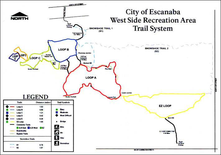 We were interested to read of the Escanaba
Pathway's newest boardwalks and new signage plus a new map. All
would be welcome additions. So we decided to check it out. Maybe we
would finally get to walk that missing Loop 3. The new map is very
nice though in studying it we realized the trails hadn't changed but
the naming had. There were now Loops A, B, C, D, and E, in addition
to that low EZ Loop through the wetlands (best traversed after
frozen and covered with deep snow). So off we went to enjoy the
newest boardwalks (truly appreciated as a lot of the area is
wetlands) and the new signs. They have indeed added some nice simple
signs which help orient one (as long as you follow the "ski" way not
the other way). The only spot completely confusing is,
unfortunately, near the beginning in a large sandy opening with no
less than five trails leading out (or in), with no signs at all! But
considering this Pathway is a result of a lot of volunteer work (in
addition to DNR and City) this is not a complaint, just an
observation. It's possible more signage is forthcoming. There were a
few other intersections we had to stop and think about, but it
really isn't too complicated a trail system. We were interested to read of the Escanaba
Pathway's newest boardwalks and new signage plus a new map. All
would be welcome additions. So we decided to check it out. Maybe we
would finally get to walk that missing Loop 3. The new map is very
nice though in studying it we realized the trails hadn't changed but
the naming had. There were now Loops A, B, C, D, and E, in addition
to that low EZ Loop through the wetlands (best traversed after
frozen and covered with deep snow). So off we went to enjoy the
newest boardwalks (truly appreciated as a lot of the area is
wetlands) and the new signs. They have indeed added some nice simple
signs which help orient one (as long as you follow the "ski" way not
the other way). The only spot completely confusing is,
unfortunately, near the beginning in a large sandy opening with no
less than five trails leading out (or in), with no signs at all! But
considering this Pathway is a result of a lot of volunteer work (in
addition to DNR and City) this is not a complaint, just an
observation. It's possible more signage is forthcoming. There were a
few other intersections we had to stop and think about, but it
really isn't too complicated a trail system.
It was a surprisingly warm day and I ended
up in shorts, enjoying the expanded "summer". We followed around
Loop A, enjoying the wonderful high ridge with beautiful big trees,
declined (with no discussion) to head out into the EZ Loop wetlands,
onto Loop B, onto C where we finally figured out the "missing" other
Loop 3, now designated as rest of C, plus D, and E. There was a
gate, as there had been, blocking what we had thought might be the
Loop 3 that we'd never found. The No Trespassing sign was still
there but added was the explanation "Sludge Ponds" -- the latter
words a pretty good deterrent to tresspassing we thought. This area
backs up to the Delta County Landfill. And just before the gate is
now a newly signed path noted as "Summer Bypass Trail". And it hit
us why. One wouldn't be able to traverse this area until the ground
(and sludge ponds??) were well frozen and covered with snow. THEN it
would allow an additional area for the cross country skiing route.
We would likely never walk that part of the Pathway, and it would be
available to skiiers only in those good winter years. Escanaba is
relatively "warm" and not known for excessive snow. But it would be
a nice addition when it happens.
We finished Loop B back to the starting
trail. One can go on around the "easy" snowshoe loop at this point
and we decided to, until we went just a little ways down into wet
ground so, on second consideration, to leave that until winter
freeze up. Back to the main Loop and the welcome, and appreciated,
very long, boardwalk across the all too common wet ground (even on
this dry season) on up the hill back to the parking lot. It is a
relatively short adventure but a quite nice Pathway, off the
sidewalks of the City.
February 8, 2022
We headed on into the Escanaba Pathway and
spent a bit over an hour walking the nice shorter (the more cleared
part) of the snowshoe trail then on around on Loop 1. A skiier came out
as we were going in and said we wouldn't need snowshoes. The trails are
only occasionally groomed and pretty beat up with the traffic (people
and dogs) and as the skiier said, it was a nearby convenient place to go
and it gets him out, but it isn't a well maintained trail. But we
appreciated the trail as he did and it was a pleasant hour's walk to
finish our day in town.
January 7, 2022 -- Escanaba Pathway on Snowshoes
We have hiked on the Escanaba Pathway with bare ground, with a little
snow, with more snow, and now there was snowshoe snow. Would the
Snowshoe Path be more easily traversed with more snow? But I really
thought that we would just walk on the Ski Paths since they are plenty
wide for snowshoeing along the edge. It was only mid teens but calm and
we were getting acclimated to the colder weather now.
As we started out a couple came back off the snowshoe trail a'foot. We
asked how the path was without snowshoes and he said it was fine, and
she said it was OK except in one area. So we decided to go with
snowshoes. We had a nice chat because theirs was the only other car in
the parking lot and it was a Subaru Impreza. We exchanged similar
enthusiasm for having a vehicle that was good in the snow since he had
also just gotten his vehicle this winter as we had.
We decided to go the Snowshoe Trail, at least as far as the shortcut to
Loop1. There were a lot of tracks, both boot and snowshoe and it was
well packed. We widened and flattened the path a little more with our
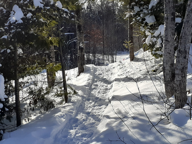
wider Iversons but the snow was soft and easy. It's a nice, pretty,
hilly trail through the woods at this point.
At the cutoff most of the traffic went that way but someone had gone on
ahead and we decided to follow. Following someone who has packed the
snow makes it easier walking which was nice. But a ways up where the
trail got brushier the lone snowshoer turned back. We could have, too.
But we decided to forge ahead. Something about the challenge I guess.
We'd been here before and knew what we were getting into, or thought we
did. Off into the deeper snow we went, breaking trail. Soon we were in
the thick tangle of cedars, fitting our snowshoes between the trunks.
Thankfully there was enough snow to cover most of the brush and small
growth underfoot.
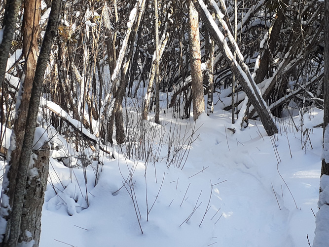
Then came the even thicker tangle of mostly dead tall thick swamp bush
clumps (alders? dogwoods?) and marsh vegetation. With age and high wind
events the trail was constantly blocked by usually dead crossed stems
and branches. So we made our way, mushing through the snow made deeper
being upon the undergrowth, through and over young whippy growth;
breaking off what we could, moving what we could, somehow getting
through what we couldn't, taking turns leading. The trail wasn't really
apparent, but looking around it was easily apparent where you couldn't
get through (all around), so you just had to take a few steps forward
into that little space, hoping it would be obvious what the next step
would be. Obvious being relative. It was certainly an adventure! Onward
we pushed. We talked about volunteering next summer to do some much
needed trail maintenance -- on bare ground!
It got worse as we got to an area that included more trees. There were
many blowdowns to get over or under (remember the Limbo?). We laughed at
our gymnastics, and at ourselves for doing this. But I kept thinking we
must be getting close to the end, by North 30th Street, where one
suddenly comes out of the dense brush into a small clear stand of red
pine, then turns to walk along the road to the clear, wide ski trail.
But we couldn't hear any traffic, nor see any pine trees above the swamp
woods. We made our way around a few blowdowns, re-finding the path, such
as it was. The sun was getting lower. Then we were confronted with a
truly major blowdown mess -- cedars and birch and hemlocks, all thick
within the thick alders and dogwoods, every which way. We looked, and
looked, but there simply was no getting around or through. We were
stopped. The trail for sure ended here, and my guess it will from now
on. We turned back.
It was easier walking since we had already broken trail and cleared out
most of the crossed stuff. We stopped at the few blue plastic trail
markers to add a note that the trail ahead was blocked (pencil worked
fine on the plastic). Then we heard voices ahead -- three
snowshoers had followed our tracks. But then they turned back, and when
we realized we were catching up to them we stopped for a break, not
wanting to intrude in their trail experience. We were glad they had
turned before it got really rough. But it was nice to know other folks
were able to make use of our breaking trail.
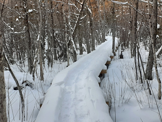
Soon we came to that cutoff for the alternate snowshoe trail, crossing
over to Loop1 of the ski trail, where almost all traffic had gone. We
followed. It turned out to be a really nice loop, hilly but not
challenging. When it came to Loop1 where it used to follow along the ski
trail the snowshoe trail made a quick turn off onto one of the new
boardwalks. Very nice!
Then back on the ski trail back to the parking lot. It was so nice to
see that on this nice wide trail there not only was plenty of room for
both skiers and snowshoers/walkers but that not one person a'foot
stepped on the ski tracks, staying to the side. People do know how to
share the trail, given the space to do so. Almost all the traffic was
a'foot but there had been two skiers go through recently. Very recently
it turned out because as we got to the parking lot the skiers came along
off their trail to their car. They had had a nice run and so had we. One
and a half hours out, and only one back. It was a good walk, and a good
workout!
November
24, 2021 -- Checking for Trail Markers on the Escanaba Pathway
An appointment in Gladstone today meant a
good excuse to head on over to the Escanaba Pathway to see if they
had put up any more trail markers. It was 45 degrees, hazily sunny,
a bit windy but no precipitation -- we just had to go for a walk
somewhere. And this was a good choice with deer hunting season still
on (no hunting within city limits). Besides, I realized we had few photos
of the Escanaba trail,
which didn't seem fair since some of the other trails we hiked often had
plenty of
photo PR. It was a good enough reason to go (not that we really
needed any excuse). We had a very nice two hour walk, meeting
several dogs and their humans, and even a woman without a dog. And
we got our photos.
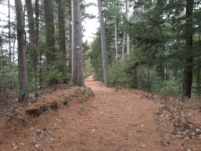
The Pathway has some real nice scenic
sections up on the ridge; always a joy to walk:
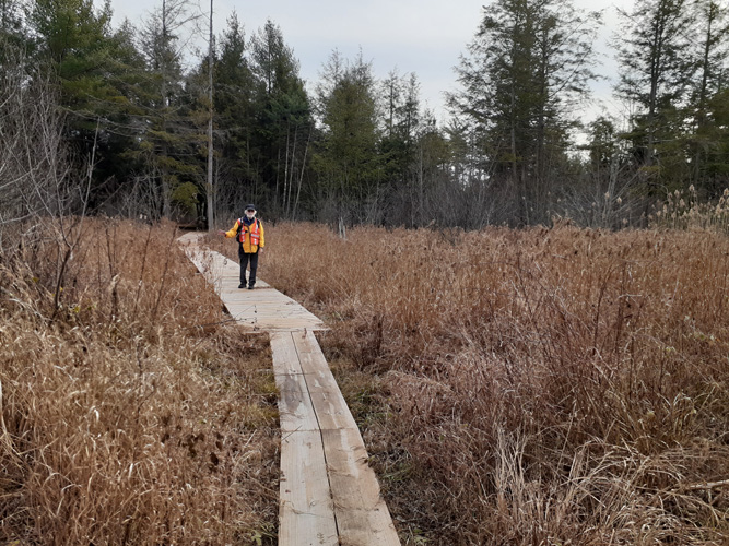
And the big news of the Pathway this year
was the 2000 feet of boardwalks put in this year and last, to
enable easier accessibility to the area which is mostly part of a
large wetlands. This most definitely upped the enjoyment of the
trail and made it possible to walk sections that even in this dry
season would have meant wet feet and churned up muddy trail (with
subsequent damage to this fragile marshland). It will be interesting
to see if the former rutted paths that the boardwalks bypass mend
and recover. Though it's not clear if the maintenance vehicles might
still run on them since they (ATVs) wouldn't be able to go on the
narrower 2-board walkways.
Signage (see our October 21 report on the
trail) -- well, there are indeed a few more signs and markers, which
helped, more or less depending on where they were. It's still often hit
and miss, with unmarked intersections and crossings, and new
bypasses not on the map (which is hard to match to the trail anyway). But
they are making progress and we applaud the effort. We did manage to
go all around Loop 1 this time, thanks to the new boardwalks, with only a few short backtracks and wonderings where we were. We
think we ended up doing Loop 2 twice, and still don't know if
unmarked Loop 3 is there or not. We did see signs that possibly they
are rerouting the snowshoe trail, which is very much needed and
would be a big improvement. There is a lot happening here with, I'm
guessing, few people doing it. But we'll be back, to enjoy the trail
and appreciate the ongoing work to make this an inviting area to
walk and ski and snowshoe. Since it was only
mid afternoon we decided this might be the day to check out the
little Days River Nature Trail on the
Kipling Road on the way home. We didn't like to leave any trail
within our area unexplored but this one was, like the Esky trail, on
low ground so we'd passed it by many times. Maybe today would be its
day.
October 21, 2021 --
Giving the Pathway Another Chance
We were in Escanaba and had time for a walk so we decided to check out
the local trail. Even though it had been a dry summer and the ground
wasn't yet frozen we figured the west/north section might be OK. We
weren't at all inclined to start at the south-east end heading through the
marsh, likely wet even now.
It was a pleasant day, cool but dry, partly
sunny. There were no cars in the parking lot so we had the Pathway
to ourselves. The signage at the beginning is a bit obscure, with
several trails leading in and out (more obvious in the winter with
ski and snowshoe tracks) but we set out on what we thought was the
right one, soon crossing a wide intersection with no signage, trying
to remember which trail went where. We planned to walk out and back
on the high ridges of the south part of Loop 1 (the north side is
lower through marshlands), then come back and walk the smaller Loops
2 & 3 which we hadn't been on before.
Thankfully, there were some blue triangle
markers, and some kind soul had written in felt pen the trail
directions. There were also short metal stakes with pink paint. As
we walked we came upon more stakes and pink paint marked trees, and
occasional blue trail markers with simple hand written directions.
They obviously were in the middle of new signage. We soon realized
that the way to go was to follow the pink paint! Which we did, with
great appreciation for the person(s) with the paint can and felt
marker. Before we made that realization we did end up going down
into the all too common marsh, looking for hummocks to step on,
trying to get through without wet feet. That wasn't working too well
so we went back and took a different path. That's when we realized
we had to follow the pink paint. And we found the first of the great
surprise of the Pathway...
New Boardwalks!! Not just one, but many;
short two board crossings and long cross board boardwalks, bypassing
or crossing over the many wet boggy spots on the trails, again and
again. What an incredible job they had done. We walked on, marveling
at the work, now enjoying the low sections as well as the beautiful
high ridges. We did the out and back on Loop 1, stopping to eat our
packed lunch at a nice sunny spot on the ridge. Then around Loop 2.
We found several blocked trails which we guessed to be Loop 3, no
longer accessible (or maybe only in the winter). Unfortunately, we
didn't have the phone camera with us to take a picture of the
beautiful boardwalks, but we sure did appreciate them. When we came
around on Loop 2 to where 1 and 2 merge we saw where they had one of
those boardwalk bypasses to skirt that wet section we had started
out on. Now that we know how nice and pleasant a trail this is now
we will make use of it on our trips to Escanaba. It will be
fun to return and walk it with signage in place.
February 3, 2021 -- Return to the Pathway
 Our
third day of beautiful sunny skies and calm. It was also the last
day before the forecasted big snow storm. Well, maybe not big but at
least it included snow which there has been very little of thus far.
A lot of snow lovers are pinning high hopes on this one. For us it
meant get out hiking before we have to don snow shoes. It was a
perfect day, cold to begin with but promise of low thirties. We
decided to try out the snowshoe trail (yellow dashes) at the
Escanaba Pathway which we hadn't been on. The map said 4 miles and
the track looked curvy enough to be interesting. And interesting it
was! Though it's really only 2 miles long (4 miles out and back). Our
third day of beautiful sunny skies and calm. It was also the last
day before the forecasted big snow storm. Well, maybe not big but at
least it included snow which there has been very little of thus far.
A lot of snow lovers are pinning high hopes on this one. For us it
meant get out hiking before we have to don snow shoes. It was a
perfect day, cold to begin with but promise of low thirties. We
decided to try out the snowshoe trail (yellow dashes) at the
Escanaba Pathway which we hadn't been on. The map said 4 miles and
the track looked curvy enough to be interesting. And interesting it
was! Though it's really only 2 miles long (4 miles out and back).
Of course, one had to find that elusive
north trail head, nicely marked on the map with no roads or
directions to it. The only directions we found was 19th Ave N behind
the Great Lakes Sports, which didn't ring a bell. Turns out we'd
been by it many times. The Great Lakes Sports was the gun/shooting
club before you get to the Delta County Landfill where we take our
recyclables. So, US2 to Danforth Rd, turn onto 19th Ave N by the big
sign for the Landfill and a faded Great Lakes Sports sign. Across on
19th and sure enough the road to the trailhead was right beside the
gun club building. Take a left at the Y to a large parking lot which
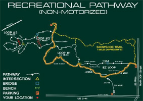
is also the trailhead for an ATV trail. There was a large map-sign
for the Recreational Pathway. And they nicely had a clean Porta-John
as well as multiple benches. One appreciates such amenities. There
were several pickups and well packed snow all around with a number
of trails to choose from. The big question was, which might be the
designated snowshoe trail?
The map was upside down to and not aimed in
the direction of the trails so was a little hard to decipher. But
while we were looking at the various options, all packed hard with
vehicle and foot tracks, we heard an ATV heading toward the parking
lot. Someone to ask! Not just a random someone, but a friendly
volunteer on a nice tracked ATV he uses to groom and maintain the
trails. We got complete directions which was good because the
"snowshoe" trail was not obvious heading up over a bare mound
between close spaced trees. But it did have a blue diamond, there
and along the trail, which with his directions we were able to
follow. There were a set of recent tracks (the only other
tracks). Real recent, it turned out, as it was a fellow who was
doing a GPS route of the Pathway that day. Plus there was heavy
equipment noise coming from the trails area as they were working on
making a new route to avoid some wet spots. This was why all the
trucks in the parking lot. The volunteer directed us around those,
closed, sections. We were the only recreationist which certainly
didn't bother us.
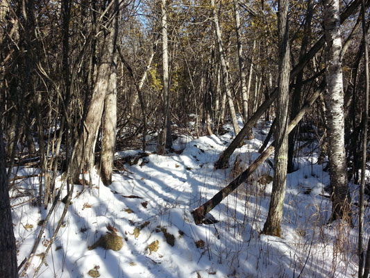 On
to the "snowshoe" trail. It started off nicely though narrowly down
between trees, curving along the edge of the ridge -- down into the
wetlands. This seems to be the fate of snowshoe trails. But the
first part of the trail was rather fun to walk as it wriggled
through a dense cedar swamp, up and over roots, hummocks and brush,
between and under leaning close spaced cedars. It was really quite
pretty with the sun coming through here and there and this was the
best time to be in there, when it was well frozen but with enough
snow for traction. One most definitely wouldn't want to try this on
showshoes! But you would find that out pretty quickly. Not only
would they catch on the debris they wouldn't fit between the trees
unless they were quite small. On
to the "snowshoe" trail. It started off nicely though narrowly down
between trees, curving along the edge of the ridge -- down into the
wetlands. This seems to be the fate of snowshoe trails. But the
first part of the trail was rather fun to walk as it wriggled
through a dense cedar swamp, up and over roots, hummocks and brush,
between and under leaning close spaced cedars. It was really quite
pretty with the sun coming through here and there and this was the
best time to be in there, when it was well frozen but with enough
snow for traction. One most definitely wouldn't want to try this on
showshoes! But you would find that out pretty quickly. Not only
would they catch on the debris they wouldn't fit between the trees
unless they were quite small.
Soon the cedars gave way to an expanse of
wetland shrubs (unfortunately mostly dead and dying) and vegetation,
much like we'd encountered on our December walk from the south
entrance, though this track wasn't quite as ankle turning. The
trail-makers had done their best to make a long trail out of a small
amount of land and it snaked tightly through the vegetation, finally
getting into an area with some cedars and a scattering of other
trees. This was certainly not a fast hike! But then we weren't in a
hurry. Back through more shrubs and marsh grasses, finally ending up
near busy North 30th Street on a bit of higher ground and a very
welcome small red pine plantation with dry ground covered in soft
pine needles. We enjoyed a small break here for drinks, snacks, and
to adjust layers (it was getting warmer, probably 32 degrees and
sunny).
Not being inclined to reverse our walk back
through the wetlands we headed across along North 30th Street to the
original east trailhead where we knew we could get on the ski trail
for the hike back. Here we found a wide, straight, nicely flattened
track straight through the wetlands to some woods up ahead where the
trail started curving and the traffic noise was blocked by the
trees. The trail was well trod with footprints here. Not surprising,
this was where folks walked. But we were happy we'd checked out the
mostly ignored no-snowshoes trail. And now we were happy for better
walking on the frozen ski (once there is more snow) track. After a half
mile of flat lowland we came to the section we had walked before,
and knew where it headed -- up onto high ground.
 This
is a real nice trail, from EZ Loop to Loop 1 as it winds up and
through a pretty hemlock and fir woods. It was getting time to stop
for lunch but we decided to wait until be got to the top of the
ridge which went up in several stages. A bit of wind now then
and the shade from the trees kept us from over-heating and we
appreciated the sun that made it through to us. And it was a nice
sunny spot that we came up upon the enticed us to stop before we got
to the highest spot. It was just too nice to pass by and we soon
settled into that spot of sun, sitting on the low trail-side bank,
eating our macaroni and cheese lunch, enjoying the view. This
is a real nice trail, from EZ Loop to Loop 1 as it winds up and
through a pretty hemlock and fir woods. It was getting time to stop
for lunch but we decided to wait until be got to the top of the
ridge which went up in several stages. A bit of wind now then
and the shade from the trees kept us from over-heating and we
appreciated the sun that made it through to us. And it was a nice
sunny spot that we came up upon the enticed us to stop before we got
to the highest spot. It was just too nice to pass by and we soon
settled into that spot of sun, sitting on the low trail-side bank,
eating our macaroni and cheese lunch, enjoying the view.
Up higher on the ridge and around Loop 1,
then north back to the parking lot. Only one truck was left and our
car, and it was earlier than we usually ended our hikes. So we
headed out towards home but first we stopped by the Days River
Pathway for a quick, easy, very pleasant walk around the first loop,
ending as the sun was heading for the horizon and it was cooling
off. It was the perfect finish to a day of hiking, and now we could
look forward to winter finally arriving with (possibly) a good
snowfall.
December
17, 2020 -- Still No Snow
It's like anything - the more you give your
attention to it (no matter what it is) the more it comes into your life.
For us right now it's happening with hiking. Need to go to Escanaba to
get some boards at Menards? Sure, there's some kind of trail right
nearby. We'd have time for a short hike. We'd passed the small
trail-head turn-out numerous times and knew it headed off into a big tag-elder (or
something similar) lowlands which didn't look too inviting but one never
knows. So we decided to check out the Escanaba
Recreational Non-motorized Pathway in person, starting at the south-east end off the back of the
Comfort Suites parking lot. Now they say it is for cross-country ski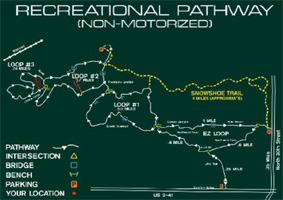 ing
and snowshoeing in the winter; and hiking, biking, running in the summer. With a couple feet of snow I'm sure it
will be a nice cross country ski trail. But the hiking, biking, running
is a bit overstated, at least at the south section.. ing
and snowshoeing in the winter; and hiking, biking, running in the summer. With a couple feet of snow I'm sure it
will be a nice cross country ski trail. But the hiking, biking, running
is a bit overstated, at least at the south section..
The
trail IS generously wide, well marked, with some nice conifer woods and
a nice ridge. But one has to first get through about 20 minutes worth
of wetlands, really wet lands, which are thankfully well frozen
right now. It is also full of frozen swamp grass
hummocks and stumps sticking up through the ice and a generous covering
of recently mowed thick dried (but very pretty) grass/sedge/reeds, with
occasional stubble, all of which we traversed like drunken sailors,
sliding a bit, walking and bouncing on and off the hummocks. We now know
we both have very good ankles! This was the "EZ Loop". But one does get
through that to Loop #1 and up onto the ridge and woods. It really was
quite a nice trail at that point, especially being somewhat warmer (than
recent outings) at about 30
deg and only a mild breeze. Loop#1 heads down and back out of the
wetlands now and then but not hummocky like the beginning (and ending)
trek. But considering what they had to work with the folks who built,
and maintain, this trail through difficult terrain have done an
admirable job and I think it might be a popular local ski trail. There
are a couple of northwest loops that look more promising for hiking,
however, with a north-west trail
head which we'll check out on a future trip to Esky.
* * * * * *
Copyright
© Susan Robishaw and Stephen Schmeck
|