January 12, 2022 (01122022) -- Return to Ashford Lake Pathway
We wondered if the Ashford Lake Pathway had any action this year so
decided to check it out. It was what seems to be our "regular" hiking
weather this year -- cloudy, teens to twenties, calm to light wind,
promise of a warmer
afternoon so we left after lunch. We have less than a foot of snow here
but there is more as one heads north. The main roads were clear which is
always nice.
When we arrived we found, as last year, the generous parking area
plowed. A few vehicles had been in; still no signs.
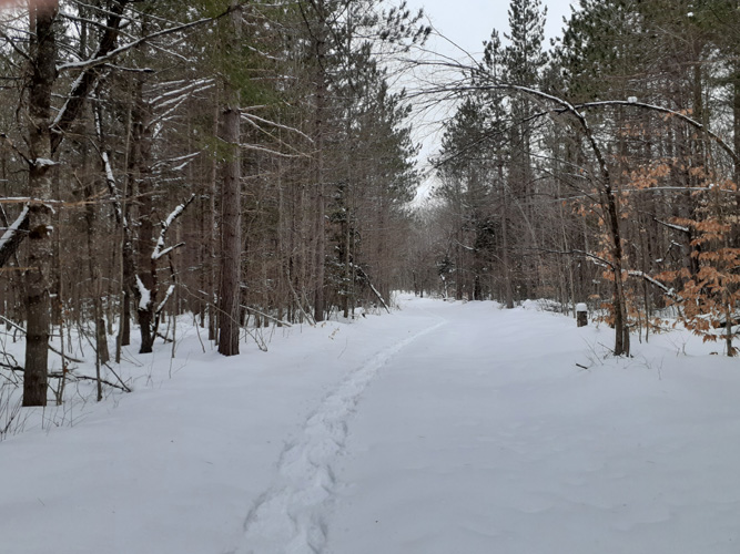 Also, as before, there had been one lone skiier, before the last
snow but the tracks were visible. Snowshoes on, we followed the ski
tracks up the well covered snowy road-wide 'Pathway', taking turns
breaking trail. It may not be particularly exciting or scenic but it's a
nice walk. Also, as before, there had been one lone skiier, before the last
snow but the tracks were visible. Snowshoes on, we followed the ski
tracks up the well covered snowy road-wide 'Pathway', taking turns
breaking trail. It may not be particularly exciting or scenic but it's a
nice walk.
We think the skiier went the north-west side of Loop1 then headed
out north on Loop2; thus we did as well. It really was guesswork but it
didn't matter. It was an easy open track to walk and we could just
follow our own tracks back if we didn't loop around in a reasonable amount
of time. Thankfully, Steve has a good sense of direction, and, most
important, a compass (it's rather funny that we both carry good Silva
compasses but what gets used most often is a cheap little key-fob
compass Steve has hooked to his jacket.)
 We
went by a couple of what might be roads or the trail, but we continued
on till we, and the skiier, came to an intersection of a "road" that had
a bit of older traffic and a more recent snowmobile. The skiier followed
that road left, but it looked like the trail crossed and continued
north. This was narrower, not cleared, more pathway-like. Not a road. Plus there
were several large trees at the entrance (rare amongst the young
cut-over woods). I voted to head on north that way, so we did, clearing a bit as we went
(compared to the Esky Snowshoe trail this was nothing!), going around a
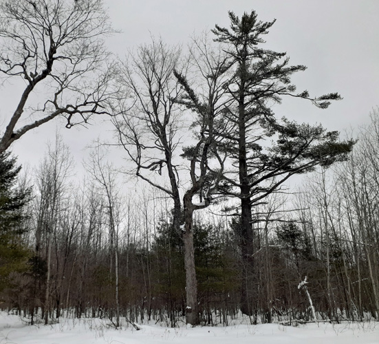
couple of downed trees. The woods were mixed second growth.
After a bit we came to maybe the end; we weren't sure, but it looked
like it might turn left. It was a path-like opening anyway. Then that
ended, sort of. To the right the "trail" went up a steep fairly large
hill (oddly placed in this flat area) where a wide swath had been cut in
the young re-growth. We could have turned back. But who knew what was
at the top! Up we went. This climb would easily match the best (to a
skiier) of any of the steep hills at Rapid River or Valley Spur! At the top we could see
that this was par We
went by a couple of what might be roads or the trail, but we continued
on till we, and the skiier, came to an intersection of a "road" that had
a bit of older traffic and a more recent snowmobile. The skiier followed
that road left, but it looked like the trail crossed and continued
north. This was narrower, not cleared, more pathway-like. Not a road. Plus there
were several large trees at the entrance (rare amongst the young
cut-over woods). I voted to head on north that way, so we did, clearing a bit as we went
(compared to the Esky Snowshoe trail this was nothing!), going around a
couple of downed trees. The woods were mixed second growth.
After a bit we came to maybe the end; we weren't sure, but it looked
like it might turn left. It was a path-like opening anyway. Then that
ended, sort of. To the right the "trail" went up a steep fairly large
hill (oddly placed in this flat area) where a wide swath had been cut in
the young re-growth. We could have turned back. But who knew what was
at the top! Up we went. This climb would easily match the best (to a
skiier) of any of the steep hills at Rapid River or Valley Spur! At the top we could see
that this was par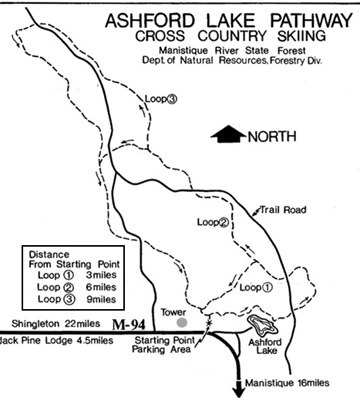 t
of a ridge, running more or less west, recently logged with clumps of
re-growing young maples. There was no trail. So what was that wide cleared
swath up the hill about? Another unanswered question. There was enough
room between the young clumps to get our snowshoes through and we had a
nice walk along the ridge. t
of a ridge, running more or less west, recently logged with clumps of
re-growing young maples. There was no trail. So what was that wide cleared
swath up the hill about? Another unanswered question. There was enough
room between the young clumps to get our snowshoes through and we had a
nice walk along the ridge.
We following the high ground for awhile then decided we better go down
and get headed southerly, giving a better chance of coming to a trail or
two-track of the Pathway area. At the bottom we headed into a nice
woods, fairly thin but with mature trees and not too much undergrowth.
Using compass bearings Steve brought us out onto one of the snow covered
roads. Were those the skiier's tracks? Maybe. It looked like snowmobile
and other traffic under the last snow. Walking east we weren't too
surprised to soon see the intersection opening ahead with the large
trees, and our tracks. At least if someone followed our trail they
would circle around and end up here, too. We guessed that we had been
within the northern area of Loop2, between the Trail Road and Loop3.
Maybe. It had been an
interesting loop, but it was also nice to walk back on our previously
tracked trail -- pretty easy snowshoeing compared to breaking trail
through unknown woods. An uneventful return trip and we were back in the
car in less than 2 hours.
February 26, 2021 -- A New Trail!
I happened upon a new trail mentioned on the
Manistique Tourism Council website. They had information on several area
hiking and cross country ski trails and I spied one I hadn't heard of --
Ashford Lake Pathway, a DNR nine mile, three loop cross country ski and
hiking trail. And only 30 miles from home! We definitely had to check
this out. I couldn't find any other information on it online, including
at the DNR website. There is a boat launch on Ashford Lake and that was
listed, but not the trail. But the Manistique site included a map
and the Pathway looked easy to find. So when we had to go into town
yesterday we decided to take along snowshoes and packs and drive up to
see what this not-promoted trail looked like. It
was a good day for it - just below freezing so the snow wouldn't be
too sticky, cloudy but not much wind. We found the trail head, or at
least what we assumed was the trail head. It was a generously plowed
out area anyway and at the right spot on the road. There were no
signs, no trail markers, no outhouse. Well, we didn't really expect
the latter, though that is always a nice touch. And the tower noted
on the map appeared to be in the wrong place but that can happen.
We walked over the lowest plow-bank and there did appear to be a set
of ski track. And it looked like a snowmobile had been through and
packed down the trail earlier. Though it had snowed since they had
been there we could still see the tracks. We decided this had to be
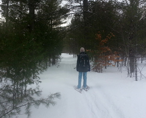
the trail. We'd follow it anyway and hope it was. So we put on our
snowshoes and packs and followed the light track of the skiier on
down the path, hoping they had only gone on the 3 mile Loop1. We
didn't want to inadvertently end up on the 6 mile Loop 2, or 9 mile
Loop 3. But without any trail markers it was a possibility,
especially on a trail we weren't familiar with.
 We
found the area to be nicely rolling with various aged mixed hardwood
stands, some more recently logged than others, most quite thick with
young re-growth, a few thin areas. We could hear a processor working
not too far away so it appeared logging was ongoing [later in the
walk we came upon logging equipment and pickups parked by a plowed
road that the trail crosses]. But it was a pleasant woods to walk
through and the final southwest part of Loop1 in particular went
through an older, not recently logged and really nice woods.
According to the map the trail does go near to Ashford Lake but we
didn't see it. We
found the area to be nicely rolling with various aged mixed hardwood
stands, some more recently logged than others, most quite thick with
young re-growth, a few thin areas. We could hear a processor working
not too far away so it appeared logging was ongoing [later in the
walk we came upon logging equipment and pickups parked by a plowed
road that the trail crosses]. But it was a pleasant woods to walk
through and the final southwest part of Loop1 in particular went
through an older, not recently logged and really nice woods.
According to the map the trail does go near to Ashford Lake but we
didn't see it.
The snowshoeing wasn't too difficult, though
we did trade off leading and breaking trail. The ski tracks faded
now and then but they were easy to follow. There were several trails
or logging roads that crossed the main trail but they were snow
covered and hadn't had any traffic. We really appreciated the
snowmobiler and skiier having gone before to give us something to
follow! The map was good and we made use of
the compass now and then to confirm we were on the right track. And
the skiier (and snowmobiler) had indeed gone around Loop1 and not
headed off onto Loop2. The wide trail (likely a logging or ATV road)
was well cleared so someone has kept it up. And the parking area was
large and well plowed. We speculated on the lack of signage or
information. Was this an old trail that the DNR has abandoned? Maybe
someone local is keeping it cleared for local use? For logging? Maybe this is
simply a "primitive" trail, kept cleared but no extras? Whatever the
reason it was a very nice trail, we appreciated it being cleared,
and we enjoyed our walk. Three miles was plenty for us on snowshoes
but it might be nice to go back when we can walk the ground and see if the
other Loops are there and find-able.
When we got home we looked up the area on
Google Satellite Maps and found the missing tower. The old "radio
tower" noted on the online map was gone but you could see the small cleared
area where it had been. There obviously has been a newer and much
larger tower built since then but it is to the
west instead of east of the trailhead. One can only see traces of
the trail on the Satellite image and there are different logging
roads but that would happen since those temporary roads come and go
over the years. But M94 and Ashford Lake and the trailhead parking
space is there, though the small loop of
road around the old tower which was labeled "tower road" is now
called "Ashford Lake Road".
* * * * * *
Copyright
© 2021 by Susan Robishaw and Stephen Schmeck
|